What happened where you live
Harm was administered by address: a grade on a 1937 map, a clause in a deed, a block marked for clearance. These tools let you look it up for Philadelphia, a city with its own reparations task force and one of the deepest open-data catalogs in the country.
 01
Look up an address
Type a street address or an owner's name. See the 1937 redlining grade, the assessment and deed history, and what public records show within a quarter mile.
Open the lookup 02Dataset catalog
All 472 datasets, searchable and filtered by theme, relevance and whether a map is available. Each links to the source record and the publisher.
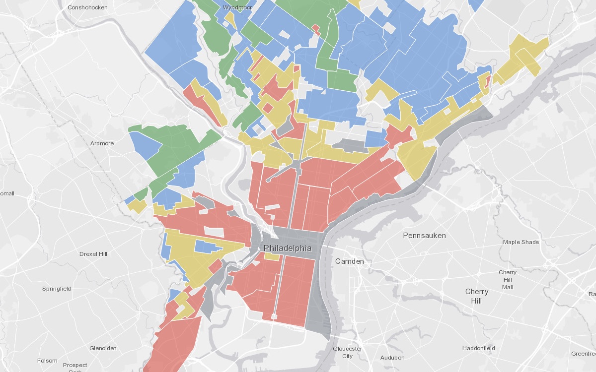
Browse the catalog 03Redlining, then and now
What the Home Owners' Loan Corporation drew on Philadelphia in 1937, what it still predicts, and how to reproduce the analysis yourself.
Read the explainer 04Philadelphia task force tracker
74 records on the Philadelphia Reparations Task Force: who sits on it, the legislation behind it, the reports it will cite, and the data it says it needs.
Open the trackerThe catalog by theme
A dataset can carry more than one theme, so the bars overlap. The darker segment is the share flagged as high relevance to reparations research. Tap a theme to open the catalog filtered to it.
Four questions the data can answer
Each path lists a handful of datasets in the order you would actually use them. Every link opens the dataset's page in this library, with a map where one exists.
Whose land is this?
Every parcel in Philadelphia has a recorded chain of owners. Start with the parcel, then the assessment history, then the deeds.
- Department of Records Property Parcels City of Philadelphia · parcel boundaries from recorded deeds
- Philadelphia Properties and Assessment History City of Philadelphia · assessed values, sale prices and owner type over time
- Real Estate Transfers City of Philadelphia · every document recorded since December 1999
- PhilaDox - Property Documents City of Philadelphia · the deed images themselves
- Philadelphia Fair Measure Volunteer · independent check on whether assessments are fair
Where was harm drawn on a map?
Some of the most consequential decisions were literally boundaries. These layers show where they fell.
- Redevelopment Certified Areas City of Philadelphia · areas the city declared blighted and eligible for clearance
- Empowerment Zones City of Philadelphia · federal zones that steered tax incentives
- Census Tracts City of Philadelphia · the unit most historical data joins to
- Police Districts City of Philadelphia · how policing is organized today
- 2020 Census to Police District Crosswalk Villanova University · join Census data to police districts
Where is displacement happening now?
Tax balances, vacancy, demolitions and code enforcement are the modern face of the same pressure.
- Real Estate Tax Balances City of Philadelphia · accounts with overdue taxes, the step before sheriff sale
- Vacant Property Indicators City of Philadelphia · likely vacant lots and buildings
- Building Demolitions City of Philadelphia · permitted and city-ordered demolitions
- Licenses and Inspections Code Violations City of Philadelphia · where enforcement lands
- Homes Saved City of Philadelphia · foreclosure prevention outcomes
- Affordable Housing Production City of Philadelphia · what has actually been built
What does the harm look like today?
Health, safety and schooling outcomes concentrate along the old lines. These are the datasets that show it.
- Shooting Victims City of Philadelphia · citywide shooting victims
- Complaints Against Police City of Philadelphia · civilian complaints and outcomes
- People Released to Philadelphia from Prison & Jail City of Philadelphia · where people return after incarceration
- Philadelphia Child Blood Lead Levels City of Philadelphia · children with elevated blood lead by area
- Heat Vulnerability by Census Tract City of Philadelphia · exposure and sensitivity to heat
- Philadelphia Vital Statistics - Social Determinants of Health (SDOH) City of Philadelphia · social determinants by planning district
- School District School Progress Report Data School District of Philadelphia · attendance, graduation and equity by school
Why this belongs on a site about micro reparations
The national argument about reparations can stay abstract forever. A deed cannot. When you know that the house you live in sat inside a red-graded area, or that the block was cleared for a university's expansion, or that the family who owned it lost it at a tax sale, the debt stops being a concept and becomes a specific thing with specific people on the other end of it.
That specificity is what makes micro reparations possible. It tells you whom to repair with, which neighborhood fund to stand behind, which displacement claim to support, and what to say when someone asks why. Philadelphia's own task force is doing this work at city scale; these tools let a person do it at the scale of one address.
A worked example
The Fels Institute's 2022 recompense report documents between 4,496 and more than 10,000 residents displaced from the Black Bottom in West Philadelphia between 1965 and 2000 by urban renewal that cleared the neighborhood for the University City Science Center. If you live, work or studied in University City, that is your address's history. The report proposes a specific program of repair. It is on the tracker.
Responsible use
- Public records onlyName search covers property ownership fields and recorded deed transfers, the records relevant to family property history. It does not search police, court, voter, employee or complaint records for people's names.
- Counts, not incidentsNeighborhood figures are counts within a quarter mile. The tools never show an individual incident tied to a person.
- Don't publish peopleLooking up your own street is research. Posting a stranger's name and address is not. Keep what you find about others private.
- Live data, your browserNothing is stored here. Records load from the City of Philadelphia's open data service and the publishers' own endpoints when you search.
Built from the OpenDataPhilly catalog (opendataphilly-jkan), Mapping Inequality at the University of Richmond, the City's open data service, and the U.S. Census Bureau. Relevance flags are keyword-based, not a judgment of any dataset. Catalog snapshot: November 8, 2026.